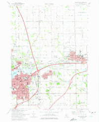
1972 Map of Holland East
USGS Topo · Published 1975About this map
Holland and Zeeland anchor this 1972 survey, showcasing the dense cultural and institutional development of these Dutch-settled communities in Ottawa County. The map provides a detailed view of the regional educational and religious landscape, highlighting Hope College, the Western Theological Seminary, and numerous parochial schools like Maplewood Christian Sch. The Macatawa River and its tributaries, including the North Branch and South Branch, flow through the terrain toward Lake Macatawa, while the historic Chesapeake And Ohio railroad line cuts through the hearts of both main settlements.
Find a feature on this map
79 named features on this map. Tap any name to fly to it.
Don’t see what you’re looking for? This feature index may not catch every label — zoom into the map to look around manually.
Map Details
Editions of this 1972 Holland East Map
2 editions found
Other maps of this area

1928 · Fennville
USGS Topo · 1:62,500

1929 · Holland
USGS Topo · 1:62,500

1931 · Fennville
USGS Topo · 1:62,500

1932 · Holland
USGS Topo · 1:62,500

1958 · Allendale
USGS Topo · 1:24,000

1958 · Allegan
USGS Topo · 1:62,500

1958 · Grandville
USGS Topo · 1:62,500

1958 · Racine
USGS Topo · 1:250,000

1958 · Grand Rapids
USGS Topo · 1:250,000

1961 · Grand Rapids
USGS Topo · 1:250,000