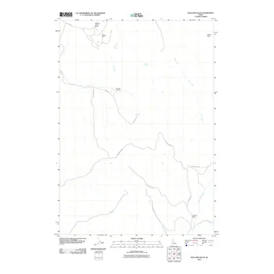
2010 Map of Holland Gulch
USGS Topo · Published 2010About this map
The Idaho Almaden Mine stands as a prominent industrial landmark in the northern reaches of this Idaho landscape, set against the uniquely named Stinking Water Basin. The terrain is defined by a network of drainages and canyons, including the notable Toe Jam Canyon and the namesake Holland Gulch. Natural water sources are scattered throughout the territory, with Toe Jam Spring and Overstreet Spring providing vital points of reference in an area otherwise characterized by seasonal or perennial flows such as Cove Creek and Little Willow Creek. Sparse road networks like Sand Hollow Rd and Skow Rd navigate the undulating geography, connecting these remote points of industry and natural significance near Wilburn Butte.
Find a feature on this map
15 named features on this map. Tap any name to fly to it.
Don’t see what you’re looking for? This feature index may not catch every label — zoom into the map to look around manually.
Map Details
Editions of this 2010 Holland Gulch Map
This is the sole edition of this map. No revisions or reprints were ever made.
Other maps of this area

1897 · Weiser
USGS Topo · 1:125,000

1952 · Weiser Cove
USGS Topo · 1:24,000

1952 · Birding Island
USGS Topo · 1:24,000

1953 · Mann Creek
USGS Topo · 1:62,500

1955 · Baker
USGS Topo · 1:250,000

1957 · Crane Creek Reservoir
USGS Topo · 1:62,500

1959 · Baker
USGS Topo · 1:250,000
1970 · Hog Cove Butte
USGS Topo · 1:24,000
1970 · Paddock Valley Reservoir
USGS Topo · 1:24,000
1970 · Sheep Ridge
USGS Topo · 1:24,000