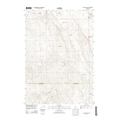
2013 Map of Holland Gulch
USGS Topo · Published 2013About this map
Stinking Water Basin and the adjacent Wilburn Butte characterize the high-country landscape at the border of Payette and Washington Counties. This 2013 survey of southwestern Idaho reveals a terrain deeply etched by seasonal watercourses, including the curiously named Toe Jam Canyon and Toe Jam Spring. The drainage patterns define local navigation, with Linson Cr and Little Willow Cr moving through the central and eastern sections. A series of deep draws, such as Heart Gulch, Ringer Gulch, and Wet Gulch, cut through the hills, while basic transport relies on rural routes like Paddock Valley Rd and Sand Hollow Rd. The map illustrates the sparsely settled, water-dependent geography of the high desert fringe during the early 21st century.
Find a feature on this map
28 named features on this map. Tap any name to fly to it.
Don’t see what you’re looking for? This feature index may not catch every label — zoom into the map to look around manually.
Map Details
Editions of this 2013 Holland Gulch Map
This is the sole edition of this map. No revisions or reprints were ever made.
Other maps of this area

1897 · Weiser
USGS Topo · 1:125,000

1952 · Weiser Cove
USGS Topo · 1:24,000

1952 · Birding Island
USGS Topo · 1:24,000

1953 · Mann Creek
USGS Topo · 1:62,500

1955 · Baker
USGS Topo · 1:250,000

1957 · Crane Creek Reservoir
USGS Topo · 1:62,500

1959 · Baker
USGS Topo · 1:250,000
1970 · Hog Cove Butte
USGS Topo · 1:24,000
1970 · Paddock Valley Reservoir
USGS Topo · 1:24,000
1970 · Sheep Ridge
USGS Topo · 1:24,000