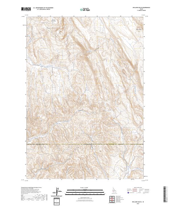
2024 Map of Holland Gulch
USGS Topo · Published 2024About this map
Stinking Water Basin and Wilburn Butte anchor the high ground in this arid corner of the Snake River drainage, where the terrain is carved by a network of drainage channels and gulches. The landscape is defined by the transition between Washington County and Payette County, marked by the north-south flow of Linson Creek and the meandering path of Little Willow Creek in the south. This area is characterized by its named canyons and springs, such as the evocatively named Toe-Jam Canyon and Toe-Jam Spring. Local transportation relies on primitive and secondary roads like Sand Hollow Rd and Paddock Valley Rd, which follow the natural contours of the gulches. The drainage patterns of Wet Gulch, Dry Gulch, and Heart Gulch reveal a complex topography of ridges and basins that have likely served as important landmarks for ranching and overland travel for generations.
Find a feature on this map
27 named features on this map. Tap any name to fly to it.
Don’t see what you’re looking for? This feature index may not catch every label — zoom into the map to look around manually.
Map Details
Editions of this 2024 Holland Gulch Map
This is the sole edition of this map. No revisions or reprints were ever made.
Other maps of this area

1897 · Weiser
USGS Topo · 1:125,000

1952 · Weiser Cove
USGS Topo · 1:24,000

1952 · Birding Island
USGS Topo · 1:24,000

1953 · Mann Creek
USGS Topo · 1:62,500

1955 · Baker
USGS Topo · 1:250,000

1957 · Crane Creek Reservoir
USGS Topo · 1:62,500

1959 · Baker
USGS Topo · 1:250,000
1970 · Hog Cove Butte
USGS Topo · 1:24,000
1970 · Paddock Valley Reservoir
USGS Topo · 1:24,000
1970 · Sheep Ridge
USGS Topo · 1:24,000