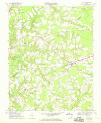
1967 Map of Holland
USGS Topo · Published 1969About this map
Holland and Carrsville anchor this rural landscape in southeastern Virginia, where the agricultural character of the late 1960s is evidenced by the VPI Research Sta and scattered rural settlements like Ducks Store. The map captures a transitional era for local transportation, showing the overlapping routes of the Norfolk Franklin and Danville, Seaboard Coast Line, and Norfolk and Western railroads. A network of wetlands, including Kingsale Swamp and Beaverdam Swamp, dictates the placement of community landmarks such as Beaverdam Ch and Laurel Hill Ch. Notable mid-century cultural markers are also preserved here, including a Drive-in Theater near Carrsville and the Southwestern High Sch serving the local population. The boundary between Isle of Wight Co and Nansemond Co runs through the northeast, marking a period before major jurisdictional changes in the Tidewater region.
Find a feature on this map
31 named features on this map. Tap any name to fly to it.
Don’t see what you’re looking for? This feature index may not catch every label — zoom into the map to look around manually.
Map Details
Editions of this 1967 Holland Map
3 editions found
Other maps of this area

1919 · Smithfield
USGS Topo · 1:62,500

1919 · Suffolk
USGS Topo · 1:62,500

1920 · Holland
USGS Topo · 1:62,500

1920 · Ivor
USGS Topo · 1:62,500

1943 · Holland
USGS Topo · 1:62,500

1944 · Windsor
USGS Topo · 1:31,680

1944 · Sedley
USGS Topo · 1:24,000

1944 · Zuni
USGS Topo · 1:24,000

1945 · Zuni
USGS Topo · 1:31,680
1945 · Sedley
USGS Topo · 1:31,680