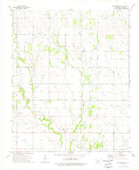
1974 Map of Hollister NE
USGS Topo · Published 1977About this map
Deep Red Creek meanders across the southern portion of this Tillman County landscape, joined by its tributaries Horse Creek and Deadman Creek. The topography in the mid-1970s is defined by a series of low-lying draws and drainage basins that intersect the vast agricultural sections. For those researching family history in the Hollister area, the presence of Dickerson Cem provides a specific point of reference in the western part of the sheet. The landscape is dotted with several Gravel Pits and Gravel Pit operations, particularly concentrated along the creek beds, indicating the small-scale mineral extraction that supported local road maintenance. This survey emphasizes the transition from the upland divides to the fertile alluvial soils of the creek bottoms, captured during a period of established farming and ranching operations before the expansion of more modern industrial agricultural practices.
Find a feature on this map
10 named features on this map. Tap any name to fly to it.
Don’t see what you’re looking for? This feature index may not catch every label — zoom into the map to look around manually.
Map Details
Editions of this 1974 Hollister NE Map
This is the sole edition of this map. No revisions or reprints were ever made.
Other maps of this area

1937 · Cache
USGS Topo · 1:48,000

1942 · Cache
USGS Topo · 1:62,500

1950 · Snyder
USGS Topo · 1:62,500

1955 · Lawton
USGS Topo · 1:250,000

1956 · Post Oak Creek
USGS Topo · 1:24,000

1956 · Manitou
USGS Topo · 1:24,000

1956 · Indiahoma
USGS Topo · 1:24,000
1956 · Cache
USGS Topo · 1:62,500

1956 · Snyder
USGS Topo · 1:62,500

1962 · Chattanooga
USGS Topo · 1:62,500