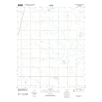
2010 Map of Hollister NW
USGS Topo · Published 2010About this map
Bethel Cemetery serves as a primary historical waypoint in this Tillman County landscape, which is defined by a systematic grid of section roads and numerous water management features. The area's drainage is dominated by the meandering course of Deadman Creek and the larger Deep Red Creek, which intersect the rigid road network at various points. A series of numbered reservoirs and dams, such as Oknoname 141008 Reservoir and Oknoname 141009 Reservoir, reflect 21st-century water storage and soil conservation efforts in this agricultural region. The map captures the subtle terrain changes around the southern waterways, including Little Deep Red Creek, where the land is carved by small tributaries feeding into the larger creek systems.
Find a feature on this map
26 named features on this map. Tap any name to fly to it.
Don’t see what you’re looking for? This feature index may not catch every label — zoom into the map to look around manually.
Map Details
Editions of this 2010 Hollister NW Map
This is the sole edition of this map. No revisions or reprints were ever made.
Other maps of this area

1950 · Snyder
USGS Topo · 1:62,500

1955 · Lawton
USGS Topo · 1:250,000

1956 · Manitou
USGS Topo · 1:24,000

1956 · Indiahoma
USGS Topo · 1:24,000

1956 · Snyder
USGS Topo · 1:62,500

1958 · Frederick
USGS Topo · 1:62,500

1964 · Tipton SE
USGS Topo · 1:24,000

1974 · Hollister NW
USGS Topo · 1:24,000

1974 · Hackberry Flat
USGS Topo · 1:24,000
1974 · Hollister
USGS Topo · 1:24,000