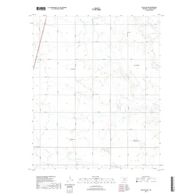
2018 Map of Hollister NW
USGS Topo · Published 2018About this map
Bethel Cem sits in the northeastern portion of this Tillman County landscape, serving as a primary cultural landmark in an area defined by its systematic section-line road network. The terrain is deeply etched by the drainage systems of Deadman Cr and Deep Red Cr, which wind through the township boundaries of t1s r17w and t1s r16w. Small impoundments like 141008 Reservoir and 141009 Reservoir are scattered across the quadrangle, illustrating the importance of water management in this agricultural region. The map reveals a strictly organized rural geography, where roads such as e1740 RD and n2280 RD intersect at regular intervals, providing a clear framework for tracing property boundaries and local family histories near Little Deep Red Cr.
Find a feature on this map
28 named features on this map. Tap any name to fly to it.
Don’t see what you’re looking for? This feature index may not catch every label — zoom into the map to look around manually.
Map Details
Editions of this 2018 Hollister NW Map
This is the sole edition of this map. No revisions or reprints were ever made.
Other maps of this area

1950 · Snyder
USGS Topo · 1:62,500

1955 · Lawton
USGS Topo · 1:250,000

1956 · Manitou
USGS Topo · 1:24,000

1956 · Indiahoma
USGS Topo · 1:24,000

1956 · Snyder
USGS Topo · 1:62,500

1958 · Frederick
USGS Topo · 1:62,500

1964 · Tipton SE
USGS Topo · 1:24,000

1974 · Hollister NW
USGS Topo · 1:24,000

1974 · Hackberry Flat
USGS Topo · 1:24,000
1974 · Hollister
USGS Topo · 1:24,000