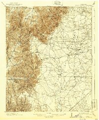
1913 Map of Hollow Springs
USGS Topo · Published 1939About this map
Bradyville and Hollow Springs anchor this 1911 survey of the upper Duck River drainage, where the landscape transitions from the higher elevations of the Cumberland Watershed toward the basin. The map reveals a dense network of early 20th-century rural life, with family-named landmarks like Wisers Store and Hickersons Store serving as local hubs. The eastern portion of the sheet is marked by the Nashville Chattanooga and St Louis RR (Sparta Br), which followed the terrain to connect remote timber or agricultural outposts.
Find a feature on this map
80 named features on this map. Tap any name to fly to it.
Don’t see what you’re looking for? This feature index may not catch every label — zoom into the map to look around manually.
Map Details
Editions of this 1913 Hollow Springs Map
4 editions found
Other maps of this area

1893 · Mc Minnville
USGS Topo · 1:125,000

1895 · Mc Minnville
USGS Topo · 1:125,000

1895 · Sewanee
USGS Topo · 1:125,000

1908 · Woodbury
USGS Topo · 1:62,500

1913 · Hollow Springs
USGS Topo · 1:62,500

1916 · Murfreesboro
USGS Topo · 1:62,500

1936 · Ovoca
USGS Topo · 1:24,000

1936 · Webbs Jungle
USGS Topo · 1:24,000

1936 · Fredonia
USGS Topo · 1:24,000

1936 · Manchester
USGS Topo · 1:24,000