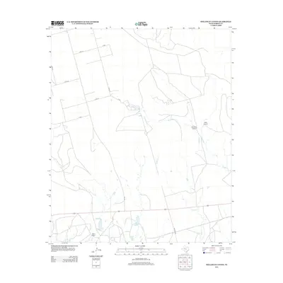
2012 Map of Holloway Canyon
USGS Topo · Published 2012About this map
Holloway Canyon cuts through the high plains of Borden County, defining a landscape shaped by intermittent water and sparse ranching infrastructure. This 2012 survey illustrates the importance of water management in West Texas through features like Johnson Tank and County Tank, which serve as vital collection points for livestock in an arid environment. The drainage network is clearly articulated, with Mesquite Cr and Grape Cr winding toward larger features like West Draw and Salt Cr in the south. The road network reflects the vast ranching tracts of the region, anchored by named routes like Muleshoe Rd and FM-1054. Local history and genealogy researchers can trace the orientation of large properties through the grid of county roads, including Co RD-124 and Co RD-127, which provide access to the remote breaks of Rock Canyon.
Find a feature on this map
19 named features on this map. Tap any name to fly to it.
Don’t see what you’re looking for? This feature index may not catch every label — zoom into the map to look around manually.
Map Details
Editions of this 2012 Holloway Canyon Map
This is the sole edition of this map. No revisions or reprints were ever made.
Other maps of this area

1954 · Big Spring
USGS Topo · 1:250,000

1958 · Big Spring
USGS Topo · 1:250,000

1969 · Beal Hollow
USGS Topo · 1:24,000

1969 · Indian Canyon NE
USGS Topo · 1:24,000

1969 · Gail
USGS Topo · 1:24,000

1969 · Indian Canyon
USGS Topo · 1:24,000

1969 · Holloway Canyon
USGS Topo · 1:24,000
1970 · Indian Canyon NW
USGS Topo · 1:24,000

1970 · Mushaway Peak
USGS Topo · 1:24,000

1970 · Sand Creek
USGS Topo · 1:24,000