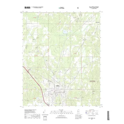
2018 Map of Holly Springs
USGS Topo · Published 2018About this map
Holly Springs serves as the focal point of this northern Mississippi landscape, where the town's historic street grid meets the sprawling timberlands of the Holly Springs National Forest. The geography is defined by the Coldwater River and its tributaries, such as Chewalla Cr and Nunnally Cr, which drain the undulating terrain of Marshall County. For those tracing family histories, the map is remarkably dense with burial sites, including Hillcrest Cem in town and more remote family or community plots like Strawberry Plains Cem, McAlexander Cem, and Bishop Cottre Cem. The northern portion of the quadrangle shows the small settlements of Atway and Hudsonville, while the road network transition from modern corridors like W Woodward Ave to rural routes such as Old Hudsonville Rd reveals how historical paths continue to shape the region's current layout.
Find a feature on this map
78 named features on this map. Tap any name to fly to it.
Don’t see what you’re looking for? This feature index may not catch every label — zoom into the map to look around manually.
Map Details
Editions of this 2018 Holly Springs Map
This is the sole edition of this map. No revisions or reprints were ever made.
Other maps of this area

1944 · Tyro
USGS Topo · 1:62,500

1944 · Potts Camp
USGS Topo · 1:62,500

1945 · Potts Camp
USGS Topo · 1:62,500

1948 · Byhalia
USGS Topo · 1:62,500

1953 · Holly Springs
USGS Topo · 1:62,500

1956 · Tupelo
USGS Topo · 1:250,000

1958 · Tupelo
USGS Topo · 1:250,000

1964 · Waterford
USGS Topo · 1:24,000

1964 · Holly Springs SE
USGS Topo · 1:24,000
1965 · Slayden
USGS Topo · 1:24,000