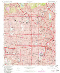
1966 Map of Hollywood
USGS Topo · Published 1982About this map
The Santa Monica Mountains and Griffith Mts rise above a dense urban landscape characterized by the burgeoning entertainment industry and academic centers of the mid-20th century. Major studio lots for Paramount Studios and Desilu Studios anchor the Hollywood district, while prominent landmarks like the Hollywood Bowl and Greek Theater occupy the northern hills. The map illustrates a highly developed transit corridor, where the Hollywood Freeway and Santa Monica Freeway cut through neighborhoods like Parklabrea and West Hollywood.
Find a feature on this map
52 named features on this map. Tap any name to fly to it.
Don’t see what you’re looking for? This feature index may not catch every label — zoom into the map to look around manually.
Map Details
Editions of this 1966 Hollywood Map
4 editions found
Other maps of this area

1894 · Los Angeles
USGS Topo · 1:62,500

1896 · Pasadena
USGS Topo · 1:62,500

1896 · Redondo
USGS Topo · 1:62,500

1896 · Santa Monica
USGS Topo · 1:62,500

1896 · Downey
USGS Topo · 1:62,500

1898 · Santa Monica
USGS Topo · 1:62,500

1899 · Downey
USGS Topo · 1:62,500

1900 · Pasadena
USGS Topo · 1:62,500

1900 · Los Angeles
USGS Topo · 1:62,500

1901 · Southern California Sheet No. 1
USGS Topo · 1:250,000