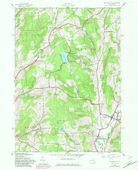
1943 Map of Holmesville
USGS Topo · Published 1983About this map
The Unadilla River forms the eastern boundary of this landscape, separating the townships of Norwich and New Berlin from Morris and Butternuts. This survey, compiled from 1942 aerial photography with later purple revisions, depicts a region defined by upland state forests and small valley settlements. The Unadilla Valley Railroad follows the river corridor, serving agricultural communities like South New Berlin and Holmesville. The interior is dotted with family-named landmarks and cemeteries, such as Wightman Cem and the S Dyer Cem, alongside small rural schools like School No 6 and School No 7. High-elevation water bodies, including Chenango Lake near Flagpole Hill and Madison Pond, feed the drainage networks of Whaupaunaucau Creek and Great Brook. This map provides a detailed view of the Chenango County interior during the mid-20th century, showing the persistence of crossroads hamlets like Kings Settlement and Amblerville.
Find a feature on this map
45 named features on this map. Tap any name to fly to it.
Don’t see what you’re looking for? This feature index may not catch every label — zoom into the map to look around manually.
Map Details
Editions of this 1943 Holmesville Map
4 editions found

Other maps of this area

1902 · Coventry
USGS Topo · 1:62,500

1903 · Norwich
USGS Topo · 1:62,500

1904 · Oxford
USGS Topo · 1:62,500

1910 · New Berlin
USGS Topo · 1:62,500

1912 · New Berlin
USGS Topo · 1:62,500

1915 · Unadilla
USGS Topo · 1:62,500

1918 · Unadilla
USGS Topo · 1:62,500

1943 · New Berlin North
USGS Topo · 1:24,000

1943 · New Berlin South
USGS Topo · 1:24,000

1943 · Gilbertsville
USGS Topo · 1:24,000