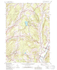
1943 Map of Holmesville
USGS Topo · Published 1994About this map
The Unadilla River valley serves as a primary corridor for development and transport during this mid-century period, defining the border between Chenango and Otsego counties. The New York Ontario and Western RR tracks parallel the river, connecting the settlements of South New Berlin and Holmesville. This rail-and-river network supported a landscape of small agricultural hamlets and local industry, evidenced by the scattered Shale Pits and the Central School serving the concentrated population at the valley floor.
Find a feature on this map
37 named features on this map. Tap any name to fly to it.
Don’t see what you’re looking for? This feature index may not catch every label — zoom into the map to look around manually.
Map Details
Editions of this 1943 Holmesville Map
4 editions found

Other maps of this area

1902 · Coventry
USGS Topo · 1:62,500

1903 · Norwich
USGS Topo · 1:62,500

1904 · Oxford
USGS Topo · 1:62,500

1910 · New Berlin
USGS Topo · 1:62,500

1912 · New Berlin
USGS Topo · 1:62,500

1915 · Unadilla
USGS Topo · 1:62,500

1918 · Unadilla
USGS Topo · 1:62,500

1943 · New Berlin North
USGS Topo · 1:24,000

1943 · New Berlin South
USGS Topo · 1:24,000

1943 · Gilbertsville
USGS Topo · 1:24,000