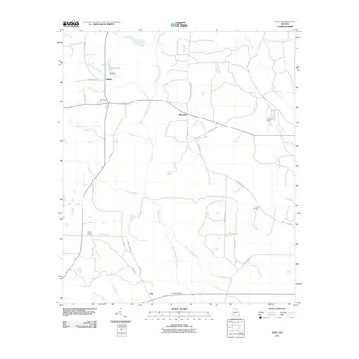
2011 Map of Holt
USGS Topo · Published 2011About this map
Gillionville and Holt anchor this agricultural landscape in southwest Georgia, where the terrain is defined by a dense network of slow-moving waterways and rural crossroads. The central corridor is dominated by Chickasawhatchee Creek and its tributary West Chickasawhatchee Creek, while Suddeth Lake and Suddeth Lake Dam sit near the northern settlement of Oak Hill. The presence of established grounds like Saint Lukes Cemetery, Spring Creek Cemetery, and Saint Paul Cemetery highlights the deep community roots in this region. This survey reflects a persistent rural character, maintained even as modern landmarks like the Tallassee Plantation Airport appear in the east. Local transit relies on a grid of named routes such as Old Thompson Rd and Laing Dirt Rd, which connect these small hubs through the surrounding woodlands and fields.
Find a feature on this map
37 named features on this map. Tap any name to fly to it.
Don’t see what you’re looking for? This feature index may not catch every label — zoom into the map to look around manually.
Map Details
Editions of this 2011 Holt Map
This is the sole edition of this map. No revisions or reprints were ever made.
Other maps of this area

1953 · Dothan
USGS Topo · 1:250,000

1954 · Dothan
USGS Topo · 1:250,000

1955 · Dothan
USGS Topo · 1:250,000

1956 · Newton
USGS Topo · 1:62,500

1956 · Sasser
USGS Topo · 1:62,500

1973 · Morgan
USGS Topo · 1:24,000

1973 · Chickasawhatchee
USGS Topo · 1:24,000

1973 · Sasser
USGS Topo · 1:24,000

1973 · Pretoria
USGS Topo · 1:24,000
1973 · Holt
USGS Topo · 1:24,000