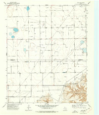
1974 Map of Holt
USGS Topo · Published 1977About this map
Hansford and Hutchinson County lands converge in this mid-1970s survey of the Texas Panhandle, a landscape defined by industrial extraction and high-plains agriculture. The small settlement of Holt sits along the southern section of the quadrangle, serving as a focal point for the surrounding network of section lines and pipelines. Natural drainage is primarily defined by the winding course of Johns Creek in the southeast corner, which provides a stark topographic contrast to the otherwise level plateau. The map is saturated with the infrastructure of the energy sector, featuring a dense distribution of Gas Wells and an occasional Oil Well, illustrating the intensive development of the local gas fields. Grounded details such as a Radio Tower and Gravel Pit further reflect the utilitarian character of the region during this era of expansion.
Find a feature on this map
8 named features on this map. Tap any name to fly to it.
Don’t see what you’re looking for? This feature index may not catch every label — zoom into the map to look around manually.
Map Details
Editions of this 1974 Holt Map
This is the sole edition of this map. No revisions or reprints were ever made.
Other maps of this area

1953 · Stinnett Station
USGS Topo · 1:24,000

1954 · Perryton
USGS Topo · 1:250,000

1954 · Amarillo
USGS Topo · 1:250,000

1958 · Perryton
USGS Topo · 1:250,000

1958 · Amarillo
USGS Topo · 1:250,000

1962 · Hansford
USGS Topo · 1:24,000

1962 · Spearman
USGS Topo · 1:24,000

1971 · Garden Springs
USGS Topo · 1:24,000

1973 · Spearman NE
USGS Topo · 1:24,000

1973 · Spearman SE
USGS Topo · 1:24,000