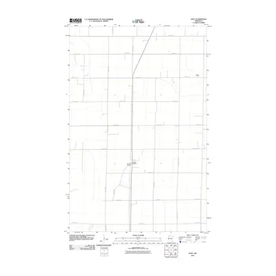
2010 Map of Holt
USGS Topo · Published 2010About this map
The small settlement of Holt serves as the focal point of this Northwest Minnesota survey, where the rigid grid of the Public Land Survey System defines the agricultural landscape. Two historic burial sites, Ringbo Cemetery in the northeast and Sandridge Cemetery just south of the town center, offer valuable reference points for genealogists and local historians tracing family lineages in Marshall County. The area’s infrastructure is characterized by a series of precise section-line roads, such as 340th Ave NE and 260th St NE, which intersect the primary north-south corridor. The presence of Old Ridge Rd suggests an older travel path that predates the modern highway system, cutting diagonally across the standard grid near the town site.
Find a feature on this map
19 named features on this map. Tap any name to fly to it.
Don’t see what you’re looking for? This feature index may not catch every label — zoom into the map to look around manually.
Map Details
Editions of this 2010 Holt Map
This is the sole edition of this map. No revisions or reprints were ever made.
Other maps of this area

1918 · Viking
USGS Topo · 1:62,500

1918 · Middle River
USGS Topo · 1:62,500

1943 · Thief River Falls
USGS Topo · 1:62,500

1952 · Thief River Falls
USGS Topo · 1:250,000

1956 · Thief River Falls
USGS Topo · 1:250,000

1957 · Thief River Falls
USGS Topo · 1:250,000

1957 · Newfolden
USGS Topo · 1:62,500

1959 · Rosewood
USGS Topo · 1:24,000
1961 · Thief River Falls NE
USGS Topo · 1:24,000
1961 · Middle River NE
USGS Topo · 1:24,000