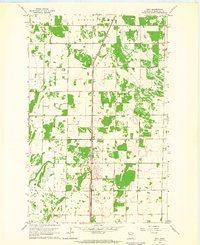
1962 Map of Holt
USGS Topo · Published 1964About this map
Great Northern tracks run straight through the center of Marshall County in the early 1960s, serving as a primary transportation artery for the rural landscape. The settlement of Holt appears as the central hub, characterized by a modest grid of streets and buildings surrounded by expansive agricultural fields and wetland pockets. Local landmarks such as Ringbo Ch and several Gravel Pits provide specific points of interest for genealogists and local historians tracing the development of this northern Minnesota community.
Find a feature on this map
10 named features on this map. Tap any name to fly to it.
Don’t see what you’re looking for? This feature index may not catch every label — zoom into the map to look around manually.
Map Details
Editions of this 1962 Holt Map
This is the sole edition of this map. No revisions or reprints were ever made.
Other maps of this area

1918 · Viking
USGS Topo · 1:62,500

1918 · Middle River
USGS Topo · 1:62,500

1943 · Thief River Falls
USGS Topo · 1:62,500

1952 · Thief River Falls
USGS Topo · 1:250,000

1956 · Thief River Falls
USGS Topo · 1:250,000

1957 · Thief River Falls
USGS Topo · 1:250,000

1957 · Newfolden
USGS Topo · 1:62,500

1959 · Rosewood
USGS Topo · 1:24,000
1961 · Thief River Falls NE
USGS Topo · 1:24,000
1961 · Middle River NE
USGS Topo · 1:24,000