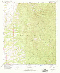
1965 Map of Holt Mountain
USGS Topo · Published 1969About this map
Pleasanton sits along the western edge of this mid-1960s study, serving as a gateway to the high elevations of the Gila National Forest and the Gila Wilderness. The terrain is defined by a dense network of canyons and gulches, including Goddard Canyon and Shelton Gulch, which drain the slopes of Holt Mountain and Wilcox Peak. This landscape reveals a history of resource extraction and backcountry management, evidenced by the Independence Mine, various unnamed Mines, and a Mine Dump near the center of the sheet. For those navigating the backcountry, the map identifies numerous reliable water sources like Cave Spring and Midnight Spring, alongside the Holt Guard Station and the Whitewater Campground. A primitive transportation network of pack trails, such as the Apache Trail and Skeleton Ridge Trail, connects these remote points with the more developed Glenwood Landing Strip and the small settlement at Pleasanton.
Find a feature on this map
72 named features on this map. Tap any name to fly to it.
Don’t see what you’re looking for? This feature index may not catch every label — zoom into the map to look around manually.
Map Details
Editions of this 1965 Holt Mountain Map
2 editions found

Other maps of this area

1910 · Mogollon
USGS Topo · 1:125,000

1912 · Mogollon
USGS Topo · 1:125,000

1954 · Clifton
USGS Topo · 1:250,000

1957 · Clifton
USGS Topo · 1:250,000

1958 · Clifton
USGS Topo · 1:250,000

1962 · Clifton
USGS Topo · 1:250,000

1963 · Bearwallow Mountain
USGS Topo · 1:24,000
1963 · Mogollon
USGS Topo · 1:24,000
1963 · Alma
USGS Topo · 1:24,000
1965 · Wilson Mountain
USGS Topo · 1:24,000