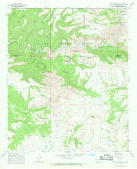
1965 Map of Wilson Mountain
USGS Topo · Published 1969About this map
The San Francisco River cuts a deep, winding course through this section of the Gila National Forest in the mid-1960s, a landscape defined by sharp elevation changes and named high points. At the northern edge, the San Francisco Hot Springs and several other Hot Springs clusters are concentrated near a Gaging Station, indicating the hydrological significance of this river canyon. To the south, the topography transitions into the distinctively named Potholes Country and high summits like Wilson Mountain and Snow Peak. Evidence of ranching life in this high-desert environment is scattered throughout the survey, from the Zumwalt Ranch and Henry Ranch to an extensive network of water catchment systems such as Blacktail Tanks, Brandy Tree Tank, and Saddle Tank. Narrow drainages including Mule Creek, Cienega Creek, and the rocky passage of The Box drain these peaks, while a Jeep Trail provides the primary access through the southern valleys.
Find a feature on this map
58 named features on this map. Tap any name to fly to it.
Don’t see what you’re looking for? This feature index may not catch every label — zoom into the map to look around manually.
Map Details
Editions of this 1965 Wilson Mountain Map
2 editions found
Other maps of this area

1910 · Mogollon
USGS Topo · 1:125,000

1912 · Mogollon
USGS Topo · 1:125,000

1913 · Morenci
USGS Topo · 1:125,000

1915 · Morenci
USGS Topo · 1:125,000

1954 · Clifton
USGS Topo · 1:250,000

1957 · Clifton
USGS Topo · 1:250,000

1958 · Clifton
USGS Topo · 1:250,000

1962 · Clifton
USGS Topo · 1:250,000

1962 · Big Lue Mts
USGS Topo · 1:62,500
1965 · Mule Creek
USGS Topo · 1:24,000