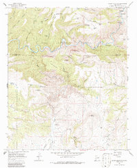
1965 Map of Wilson Mountain
USGS Topo · Published 1986About this map
The San Francisco River carves a serpentine path through the heart of the Gila National Forest, defining the wild landscape of the mid-1960s. This survey, conducted shortly before the 1965 field check, highlights the importance of water management and natural thermal features in this high-desert environment. Along the river, the San Francisco Hot Springs and a Hot Spring Gaging Sta point to the area's geothermal activity and hydraulic monitoring. The map documents the isolated agricultural and ranching life of the era, recording family-named locations such as Zumwalt Ranch and Henry Ranch. Significant landmarks including Wilson Mountain, Hanna Mountain, and the descriptive Potholes Country reveal a geography marked by deep canyons and prominent peaks like Snow Peak. Numerous stock tanks, such as Brandy Tree Tank and Ringtail Tank, are scattered throughout, illustrating the infrastructure required for cattle operations in the high country.
Find a feature on this map
56 named features on this map. Tap any name to fly to it.
Don’t see what you’re looking for? This feature index may not catch every label — zoom into the map to look around manually.
Map Details
Editions of this 1965 Wilson Mountain Map
2 editions found
Other maps of this area

1910 · Mogollon
USGS Topo · 1:125,000

1912 · Mogollon
USGS Topo · 1:125,000

1913 · Morenci
USGS Topo · 1:125,000

1915 · Morenci
USGS Topo · 1:125,000

1954 · Clifton
USGS Topo · 1:250,000

1957 · Clifton
USGS Topo · 1:250,000

1958 · Clifton
USGS Topo · 1:250,000

1962 · Clifton
USGS Topo · 1:250,000

1962 · Big Lue Mts
USGS Topo · 1:62,500
1965 · Mule Creek
USGS Topo · 1:24,000