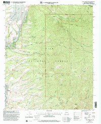
1999 Map of Holt Mountain
USGS Topo · Published 2002About this map
Pleasanton sits along the western edge of this 1990s revision, serving as a gateway to the steep canyons and high peaks of the Gila National Forest. The landscape is dominated by the complex drainage of Whitewater Creek and its southern fork, which carve deep into the Gila Wilderness. A history of high-country resource extraction is evident in the scattered mining sites found within the interior, such as Red Shaft and the Independence Mine located on the slopes of Sheridan Mountain.
Find a feature on this map
68 named features on this map. Tap any name to fly to it.
Don’t see what you’re looking for? This feature index may not catch every label — zoom into the map to look around manually.
Map Details
Editions of this 1999 Holt Mountain Map
This is the sole edition of this map. No revisions or reprints were ever made.
Other maps of this area

1910 · Mogollon
USGS Topo · 1:125,000

1912 · Mogollon
USGS Topo · 1:125,000

1954 · Clifton
USGS Topo · 1:250,000

1957 · Clifton
USGS Topo · 1:250,000

1958 · Clifton
USGS Topo · 1:250,000

1962 · Clifton
USGS Topo · 1:250,000

1963 · Bearwallow Mountain
USGS Topo · 1:24,000
1963 · Mogollon
USGS Topo · 1:24,000
1963 · Alma
USGS Topo · 1:24,000
1965 · Wilson Mountain
USGS Topo · 1:24,000