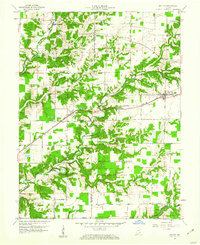
1959 Map of Holton
USGS Topo · Published 1976About this map
Muscatatuck State School and the expansive Jefferson Proving Ground dominate the rural landscape of western Ripley and eastern Jennings counties during the late 1950s. This survey illustrates a region defined by its creek valleys and the heavy influence of institutional and military land use alongside traditional farming. The Baltimore and Ohio railroad serves as the primary transit corridor, linking settlements like Nebraska and Holton.
Find a feature on this map
31 named features on this map. Tap any name to fly to it.
Don’t see what you’re looking for? This feature index may not catch every label — zoom into the map to look around manually.
Map Details
Editions of this 1959 Holton Map
4 editions found
Other maps of this area

1942 · Columbus
USGS Topo · 1:125,000

1946 · Versailles
USGS Topo · 1:24,000

1946 · Osgood
USGS Topo · 1:24,000

1953 · Cincinnati
USGS Topo · 1:250,000

1956 · Louisville
USGS Topo · 1:250,000

1957 · Cincinnati
USGS Topo · 1:250,000

1957 · Butlerville
USGS Topo · 1:24,000

1958 · Millhousen
USGS Topo · 1:24,000

1958 · Westport
USGS Topo · 1:24,000

1959 · Holton
USGS Topo · 1:24,000