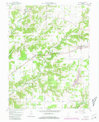
1959 Map of Holton
USGS Topo · Published 1981About this map
The U S Military Reservation Jefferson Proving Ground dominates the southern landscape of this mid-century survey, illustrating the significant federal footprint in Ripley and Jennings Counties. North of this restricted zone, the Baltimore and Ohio railroad corridor serves as the primary axis for local commerce, connecting the settlements of Nebraska and Holton. The terrain is defined by the winding paths of Otter Creek and the Vernon Fork of the Muscatatuck River, which cut through a mosaic of small-scale farms and woodlots. Genealogists will find a wealth of early burial grounds, including the Old Zenas Cem near Zenas and the Old Hopewell Cem further east. The map also captures the Brush Creek State Fish and Wildlife Area, reflecting the region's managed natural resources alongside the active industrial presence of a Quarry near the railroad tracks.
Find a feature on this map
34 named features on this map. Tap any name to fly to it.
Don’t see what you’re looking for? This feature index may not catch every label — zoom into the map to look around manually.
Map Details
Editions of this 1959 Holton Map
4 editions found
Other maps of this area

1942 · Columbus
USGS Topo · 1:125,000

1946 · Versailles
USGS Topo · 1:24,000

1946 · Osgood
USGS Topo · 1:24,000

1953 · Cincinnati
USGS Topo · 1:250,000

1956 · Louisville
USGS Topo · 1:250,000

1957 · Cincinnati
USGS Topo · 1:250,000

1957 · Butlerville
USGS Topo · 1:24,000

1958 · Millhousen
USGS Topo · 1:24,000

1958 · Westport
USGS Topo · 1:24,000

1959 · Holton
USGS Topo · 1:24,000