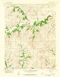
1960 Map of Holton SE
USGS Topo · Published 1961About this map
The rolling hills of eastern Kansas define this 1960 topographic study of the borderlands between Jackson and Jefferson Counties. The landscape is carved by a dense network of waterways, most notably North Cedar Creek and South Cedar Creek, which dictate the rural settlement patterns through the townships of Cedar, Delaware, and Rock Creek. Cultural landmarks are centered on local gatherings and memorial sites, such as Griggs Chapel Cem in the north and the United Brethren Ch near the map's center.
Find a feature on this map
16 named features on this map. Tap any name to fly to it.
Don’t see what you’re looking for? This feature index may not catch every label — zoom into the map to look around manually.
Map Details
Editions of this 1960 Holton SE Map
2 editions found
Other maps of this area

1886 · Oskaloosa
USGS Topo · 1:125,000

1888 · Oskaloosa
USGS Topo · 1:125,000

1889 · Topeka
USGS Topo · 1:125,000

1894 · Oskaloosa
USGS Topo · 1:125,000

1894 · Topeka
USGS Topo · 1:125,000

1950 · Kansas City
USGS Topo · 1:250,000

1951 · Ozawkie
USGS Topo · 1:24,000

1952 · Elmont
USGS Topo · 1:24,000
1952 · Meriden
USGS Topo · 1:24,000

1954 · Kansas City
USGS Topo · 1:250,000