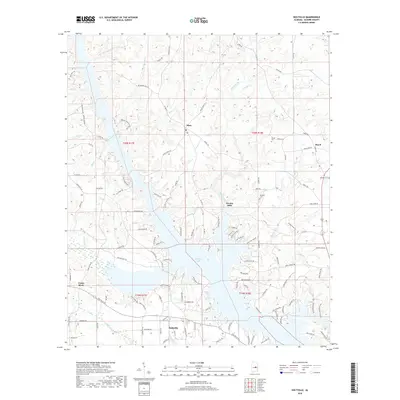
2018 Map of Holtville
USGS Topo · Published 2018About this map
Mitchell Lake and the Coosa River anchor this central Alabama landscape, where the water is met by a complex network of rural roads and established settlements. In the southern portion, Holtville serves as a primary hub, situated near the confluence of Pigeonroost Cr and Callaway Cr. The terrain is characterized by numerous small drainages such as Weoka Creek and Dunlap Cr that feed into the larger river system, reflecting a topography defined by both natural watercourses and the artificial impoundment of the lake.
Find a feature on this map
128 named features on this map. Tap any name to fly to it.
Don’t see what you’re looking for? This feature index may not catch every label — zoom into the map to look around manually.
Map Details
Editions of this 2018 Holtville Map
This is the sole edition of this map. No revisions or reprints were ever made.
Other maps of this area

1901 · Wetumpka
USGS Topo · 1:125,000

1901 · Wetumpka
USGS Topo · 1:62,500

1903 · Wetumpka
USGS Topo · 1:125,000

1953 · Montgomery
USGS Topo · 1:250,000

1956 · Montgomery
USGS Topo · 1:250,000

1957 · Montgomery
USGS Topo · 1:250,000
1959 · Wetumpka
USGS Topo · 1:62,500

1959 · Elmore
USGS Topo · 1:62,500

1971 · Richville
USGS Topo · 1:24,000
1971 · Mitchell Dam
USGS Topo · 1:24,000