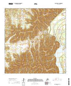
2017 Map of Holy Cross A-3 SE
USGS Topo · Published 2017About this map
The Yukon River dominates the eastern edge of this landscape, its wide channel and shifting hydrology marked by features like Big Bend Slough and Horse Island. To the west, the terrain rises sharply into a series of prominent elevations, including the Holy Cross Hills and the southern Paimiut Hills, which overlook the river valley. The topography is defined by the steep ascents of Monocline Bluff and Channel Bluff, where the river has cut deep into the surrounding landforms over time. Further south, the peak of Tabernacle Mtn serves as a significant landmark in this sparsely settled region. Small interior water bodies like Crooked Lake are situated in the low-lying basins between these ridges, illustrating the complex drainage patterns typical of the Alaska interior.
Find a feature on this map
15 named features on this map. Tap any name to fly to it.
Don’t see what you’re looking for? This feature index may not catch every label — zoom into the map to look around manually.
Map Details
Editions of this 2017 Holy Cross A-3 SE Map
This is the sole edition of this map. No revisions or reprints were ever made.
Other maps of this area

1947 · Russian Mission
USGS Topo · 1:250,000

1950 · Russian Mission
USGS Topo · 1:250,000

1951 · Holy Cross
USGS Topo · 1:250,000

1952 · Holy Cross A-2
USGS Topo · 1:63,360

1952 · Holy Cross A-3
USGS Topo · 1:63,360

1952 · Holy Cross
USGS Topo · 1:250,000

1952 · Russian Mission D-3
USGS Topo · 1:63,360

1952 · Russian Mission D-4
USGS Topo · 1:63,360

1980 · Russian Mission
USGS Topo · 1:250,000
2017 · Russian Mission D-4 NE
USGS Topo · 1:25,000