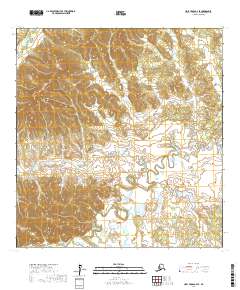
2017 Map of Holy Cross A-4 SE
USGS Topo · Published 2017About this map
Stuyahok River and its surrounding wetlands dominate the northwestern corner of this 2017 study of the Yukon-Koyukuk region. The landscape is defined by the complex, winding course of Mountain Creek, which snakes through the central and southern sections of the quadrangle, illustrating the intricate drainage patterns of the Alaskan interior. In the south, the presence of Pickens Slough near the edge of the survey indicates a low-lying, water-heavy environment where seasonal changes likely shift the boundaries between land and stream. This digital survey from the U.S. Geological Survey provides a precise view of the topography before contemporary environmental shifts further alter these remote waterways.
Find a feature on this map
12 named features on this map. Tap any name to fly to it.
Don’t see what you’re looking for? This feature index may not catch every label — zoom into the map to look around manually.
Map Details
Editions of this 2017 Holy Cross A-4 SE Map
This is the sole edition of this map. No revisions or reprints were ever made.
Other maps of this area

1947 · Russian Mission
USGS Topo · 1:250,000

1950 · Russian Mission
USGS Topo · 1:250,000

1951 · Holy Cross
USGS Topo · 1:250,000

1952 · Holy Cross A-4
USGS Topo · 1:63,360

1952 · Holy Cross A-3
USGS Topo · 1:63,360

1952 · Holy Cross
USGS Topo · 1:250,000

1952 · Russian Mission D-4
USGS Topo · 1:63,360
1952 · Russian Mission D-5
USGS Topo · 1:63,360

1980 · Russian Mission
USGS Topo · 1:250,000
2017 · Russian Mission D-4 NW
USGS Topo · 1:25,000