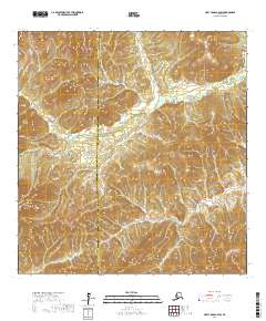
2017 Map of Holy Cross A-4 SW
USGS Topo · Published 2017About this map
Stuyahok sits at the heart of this landscape, marking a point of human presence within the drainage basin of the Stuyahok River. The map illustrates a complex topographical divide where the Kusilvak and Yukon-Koyukuk Census Areas meet. The terrain is characterized by significant elevation changes, rising from the river valley toward the Ilivit Mountains in the southwest corner. The presence of Chase Mtn adds a distinct vertical landmark to this interior Alaskan region. The surveying by the U.S. Geological Survey details the township and range boundaries that overlay this remote environment, providing a structured view of the land as it was documented in the early twenty-first century. This sheet is particularly useful for understanding the hydrography and elevation contours that dictate the movement of water and travel through the northern interior.
Find a feature on this map
11 named features on this map. Tap any name to fly to it.
Don’t see what you’re looking for? This feature index may not catch every label — zoom into the map to look around manually.
Map Details
Editions of this 2017 Holy Cross A-4 SW Map
This is the sole edition of this map. No revisions or reprints were ever made.
Other maps of this area

1947 · Russian Mission
USGS Topo · 1:250,000

1950 · Russian Mission
USGS Topo · 1:250,000

1951 · Holy Cross
USGS Topo · 1:250,000

1951 · Holy Cross A-5
USGS Topo · 1:63,360

1952 · Holy Cross A-4
USGS Topo · 1:63,360

1952 · Holy Cross
USGS Topo · 1:250,000
1952 · Russian Mission D-6
USGS Topo · 1:63,360
1952 · Russian Mission D-5
USGS Topo · 1:63,360
1952 · Holy Cross A-5
USGS Topo · 1:63,360

1980 · Russian Mission
USGS Topo · 1:250,000