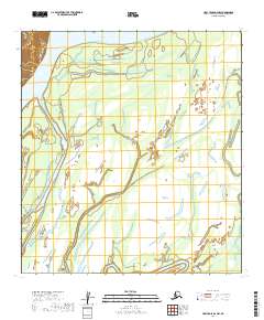
2019 Map of Holy Cross D-2 NW
USGS Topo · Published 2019About this map
The Yukon River dominates this portion of the Alaskan interior, carving a complex network of braided channels and expansive sandbars through the landscape. This 2019 survey documents the shifting hydrography of the river corridor, highlighting the significant landmass of Eagle Island as it sits amidst the moving currents. The map reveals the intricate nature of the river's path, where seasonal fluctuations and silt deposition constantly redefine the boundaries between land and water. Beyond the riverbanks, the terrain transitions into a mosaic of wetlands and low-lying marshes, illustrated through detailed topographic contours. This document serves as a precise record of the remote Yukon-Koyukuk Census Area, capturing a snapshot of a natural environment largely untouched by permanent human infrastructure or road networks.
Find a feature on this map
11 named features on this map. Tap any name to fly to it.
Don’t see what you’re looking for? This feature index may not catch every label — zoom into the map to look around manually.
Map Details
Editions of this 2019 Holy Cross D-2 NW Map
This is the sole edition of this map. No revisions or reprints were ever made.
Other maps of this area

1951 · Unalakleet
USGS Topo · 1:250,000

1951 · Holy Cross
USGS Topo · 1:250,000

1952 · Unalakleet A-2
USGS Topo · 1:63,360

1952 · Unalakleet A-3
USGS Topo · 1:63,360

1952 · Holy Cross D-2
USGS Topo · 1:63,360

1952 · Holy Cross D-3
USGS Topo · 1:63,360

1952 · Unalakleet
USGS Topo · 1:250,000

1952 · Holy Cross
USGS Topo · 1:250,000

1964 · Unalakleet
USGS Topo · 1:250,000
2016 · Unalakleet A-3 SE
USGS Topo · 1:25,000