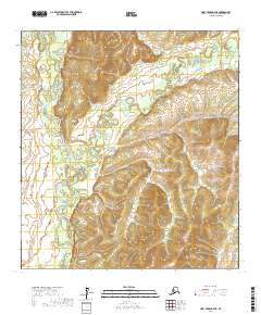
2017 Map of Holy Cross D-4 NE
USGS Topo · Published 2017About this map
Anvik River and Yellow River dominate this interior Alaskan landscape, their complex, winding courses revealing the dynamic nature of the Yukon-Koyukuk region. The hydrology shows a dense network of oxbows and abandoned meanders, indicating a terrain that is constantly reshaped by seasonal water movement and shifting banks. These rivers served as critical historical corridors for travel and subsistence, with the map providing a detailed view of the natural topography before any significant modern development or road infrastructure reached this section of the wilderness. This survey is particularly useful for understanding the exact drainage patterns and land contours within the Public Land Survey System townships, including t33n r60w and t34n r60w.
Find a feature on this map
8 named features on this map. Tap any name to fly to it.
Don’t see what you’re looking for? This feature index may not catch every label — zoom into the map to look around manually.
Map Details
Editions of this 2017 Holy Cross D-4 NE Map
This is the sole edition of this map. No revisions or reprints were ever made.
Other maps of this area

1951 · Unalakleet
USGS Topo · 1:250,000

1951 · Holy Cross
USGS Topo · 1:250,000

1952 · Unalakleet A-4
USGS Topo · 1:63,360

1952 · Unalakleet A-3
USGS Topo · 1:63,360

1952 · Holy Cross D-4
USGS Topo · 1:63,360

1952 · Holy Cross D-3
USGS Topo · 1:63,360

1952 · Unalakleet
USGS Topo · 1:250,000

1952 · Holy Cross
USGS Topo · 1:250,000

1964 · Unalakleet
USGS Topo · 1:250,000
2015 · Unalakleet A-3 SW
USGS Topo · 1:25,000