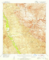
1949 Map of Holy Joe Peak
USGS Topo · Published 1955About this map
San Pedro River ranching and mining operations define this mid-century survey of the Galiuro Mountain foothills. The landscape is marked by the historical legacy of the Camp Grant Military Res (Aband) and the Old Camp Grant Military Road, indicating the area's strategic importance during the 19th-century frontier era. Significant family holdings and seasonal camps are scattered throughout the canyons, including the Eskimazene Ranch, Wagner Ranch, and Kelleys Camp, providing a detailed look at land use before modern consolidation.
Find a feature on this map
76 named features on this map. Tap any name to fly to it.
Don’t see what you’re looking for? This feature index may not catch every label — zoom into the map to look around manually.
Map Details
Editions of this 1949 Holy Joe Peak Map
2 editions found

Other maps of this area

1910 · Ray
USGS Topo · 1:62,500

1911 · Winkelman
USGS Topo · 1:125,000

1913 · Winkelman
USGS Topo · 1:125,000

1915 · Christmas
USGS Topo · 1:62,500

1917 · Christmas
USGS Topo · 1:62,500

1938 · Galiuro Mts
USGS Topo · 1:48,000

1938 · Klondyke
USGS Topo · 1:48,000

1943 · Galiuro Mts
USGS Topo · 1:62,500

1943 · Klondyke
USGS Topo · 1:62,500

1948 · Clark Ranch
USGS Topo · 1:24,000