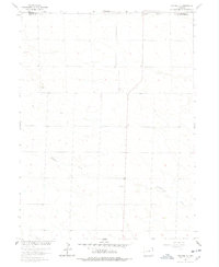
1962 Map of Holyoke NE
USGS Topo · Published 1978About this map
Wildhorse Creek meanders through this agricultural landscape in northeastern Colorado, defining much of the local topography during the early 1960s. The survey illustrates a rural region organized by a strict grid system, where the boundary between Sedgwick and Phillips Counties cuts across the northern reaches. This document was produced as part of the Department of the Interior's effort to develop the Missouri River Basin, capturing the area's transition into mid-century modernized farming. Local infrastructure is sparse but specific, marked by the presence of industrial Storage Bins and Gravel Pits that suggest the primary economic activities of the period. Fine red dashed lines indicate selected fence lines, providing a detailed look at property divisions and land use patterns that are often lost in more generalized modern mapping.
Find a feature on this map
4 named features on this map. Tap any name to fly to it.
Don’t see what you’re looking for? This feature index may not catch every label — zoom into the map to look around manually.
Map Details
Editions of this 1962 Holyoke NE Map
2 editions found
Other maps of this area

1952 · Julesburg SW
USGS Topo · 1:24,000

1952 · Julesburg SE
USGS Topo · 1:24,000

1954 · Sterling
USGS Topo · 1:250,000

1958 · Sterling
USGS Topo · 1:250,000

1962 · Venango SW
USGS Topo · 1:24,000

1962 · Holyoke NE
USGS Topo · 1:24,000

1962 · Amherst
USGS Topo · 1:24,000

1962 · Holyoke NW
USGS Topo · 1:24,000

1971 · Paoli
USGS Topo · 1:24,000

1971 · Amherst SW
USGS Topo · 1:24,000