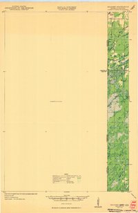
1949 Map of Holyoke
USGS Topo · Published 1949About this map
The boundary between Minnesota and Wisconsin dominates this unusual planimetric survey, which leaves the western portion as a large UNSURVEYED AREA. The eastern margin captures the narrow corridor of development and drainage where Douglas and Pine counties meet. The rail infrastructure of the Minneapolis St Paul and Sault Ste Marie line cuts through the northern landscape near Foxboro, providing a vital link for the scattered rural outposts. Local educational history is anchored by the Nelson Sch, situated amidst a terrain defined by complex water systems, including Balsam Creek and the headwaters of the Black River. The presence of Black Lake and various smaller streams like Hay Cr and Dairyland Cr indicates a landscape primarily utilized for its timber and water resources during the late 1940s.
Find a feature on this map
15 named features on this map. Tap any name to fly to it.
Don’t see what you’re looking for? This feature index may not catch every label — zoom into the map to look around manually.
Map Details
Editions of this 1949 Holyoke Map
2 editions found
Other maps of this area

1915 · Superior
USGS Topo · 1:48,000

1917 · Superior
USGS Topo · 1:62,500

1949 · Danbury
USGS Topo · 1:48,000

1949 · Holyoke
USGS Topo · 1:48,000

1949 · Webb Lake
USGS Topo · 1:48,000

1949 · Patzau
USGS Topo · 1:48,000

1953 · Duluth
USGS Topo · 1:250,000

1954 · Borea
USGS Topo · 1:24,000

1954 · Foxboro
USGS Topo · 1:24,000

1954 · Wrenshall
USGS Topo · 1:24,000