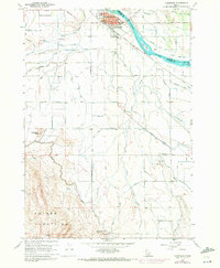
1958 Map of Homedale
USGS Topo · Published 1972About this map
Homedale sits at the northern edge of this Owyhee County study, where the Snake River defines the boundary with Canyon County. The landscape is characterized by an intricate network of irrigation and drainage infrastructure, including the Deer Flat Low Line Canal, A Line Canal, and Hogg Canal Drain, which transform the high desert into productive agricultural land. This water management system supports the nearby Labor Camp and the residential area of Owyhee Heights.
Find a feature on this map
51 named features on this map. Tap any name to fly to it.
Don’t see what you’re looking for? This feature index may not catch every label — zoom into the map to look around manually.
Map Details
Editions of this 1958 Homedale Map
2 editions found

Other maps of this area

1892 · Silver City
USGS Topo · 1:125,000

1894 · Silver City
USGS Topo · 1:125,000

1898 · Nampa
USGS Topo · 1:125,000

1898 · Silver City
USGS Topo · 1:125,000

1906 · Mitchell Butte
USGS Topo · 1:125,000

1955 · Boise
USGS Topo · 1:250,000

1957 · Opalene Gulch
USGS Topo · 1:24,000

1957 · Wilder
USGS Topo · 1:24,000

1957 · Sands Basin
USGS Topo · 1:62,500

1957 · Notus
USGS Topo · 1:24,000