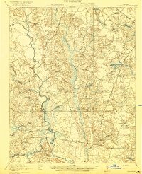
1920 Map of Homeville
USGS Topo · Published 1920About this map
The Nottoway River meanders through the heart of the coastal plain in this 1918 survey, defining the landscape of Sussex and Southampton counties. This era reveals a rural society structured around small farming communities, country churches, and a dense network of swampy lowlands like Chinquapin Swamp and Assamoosick Swamp. The transportation of the day is marked by the historical Plank Road and strategic river crossings such as Peters Bridge. Rail infrastructure is prominent, with the Southern, Virginian, and Norfolk and Western lines cutting through the territory, supporting timber and agricultural transport. For genealogists, the map is remarkably detailed, locating numerous local institutions like Hickory Hill School, Oak Grove Church, and Applewhite Church. Several millponds, including Harris Millpond and Airfield Millpond, indicate the early industry of the region before the widespread modernization of water systems.
Find a feature on this map
50 named features on this map. Tap any name to fly to it.
Don’t see what you’re looking for? This feature index may not catch every label — zoom into the map to look around manually.
Map Details
Editions of this 1920 Homeville Map
3 editions found
Other maps of this area

1894 · Petersburg
USGS Topo · 1:62,500

1919 · Jarratt
USGS Topo · 1:62,500

1919 · Surry
USGS Topo · 1:62,500

1919 · Disputanta
USGS Topo · 1:62,500

1919 · Homeville
USGS Topo · 1:48,000

1919 · Boykins
USGS Topo · 1:48,000

1919 · Arringdale
USGS Topo · 1:48,000

1920 · Holland
USGS Topo · 1:62,500

1920 · Ivor
USGS Topo · 1:62,500

1920 · Homeville
USGS Topo · 1:62,500