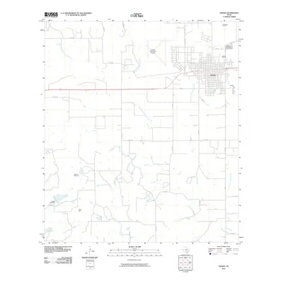
2010 Map of Hondo
USGS Topo · Published 2010About this map
Hondo serves as the focal point of this Medina County landscape, exhibiting a structured grid of streets north of its primary east-west transportation corridor. The town’s history is anchored by its local landmarks, including the Cottonwood Cemetery to the north and the clustered Oakwood Cemetery and Ingleside Cemetery near the heart of the settlement. Beyond the town limits, the terrain is defined by a dendritic network of waterways including West Tehuacana Creek and the multiple branches of Live Oak Creek. Agricultural and water management patterns are evident through features like Mumme Lake Dam and Collins Lake Dam. In the northwest, the Hondo Municipal Airport occupies a significant footprint, while the southwestern portion of the map is marked by the prominence of Fohn Hill.
Find a feature on this map
33 named features on this map. Tap any name to fly to it.
Don’t see what you’re looking for? This feature index may not catch every label — zoom into the map to look around manually.
Map Details
Editions of this 2010 Hondo Map
This is the sole edition of this map. No revisions or reprints were ever made.
Other maps of this area

1928 · Frio Town
USGS Topo · 1:62,500

1954 · San Antonio
USGS Topo · 1:250,000

1956 · Sabinal
USGS Topo · 1:62,500

1956 · New Fountain
USGS Topo · 1:62,500

1957 · San Antonio
USGS Topo · 1:250,000
1964 · Biry
USGS Topo · 1:24,000

1964 · Yancey
USGS Topo · 1:24,000

1969 · Sabinal NE
USGS Topo · 1:24,000
1969 · Quihi
USGS Topo · 1:24,000
1969 · Mustang Valley
USGS Topo · 1:24,000