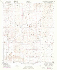
1949 Map of Hondo Reservoir
USGS Topo · Published 1979About this map
Rio Hondo defines the hydraulic character of this Chaves County landscape, where an intricate network of levees and canals once attempted to harness the semi-arid terrain. The central focus is the Hondo Reservoir, noted as abandoned by the time of the late-1940s survey, alongside the similarly defunct Hondo Irrigation Project. These features, along with the Hondo Reservoir Diversion Canal and Hondo (Old Channel), suggest a period of significant water engineering that preceded the mid-century mapping. Scattered across the draws and arroyos are numerous traces of human history and settlement. Researchers will find family-named landmarks such as Woods Ranch, Bloom Ranch, and Sherman Place, alongside notable archaeological markers like the Missouri Plaza Indian Ruins and other Indian Ruins. The map also details early utility features like the Red House Well and Bloom Well, providing a look at the infrastructure required for ranching in this part of New Mexico.
Find a feature on this map
31 named features on this map. Tap any name to fly to it.
Don’t see what you’re looking for? This feature index may not catch every label — zoom into the map to look around manually.
Map Details
Editions of this 1949 Hondo Reservoir Map
2 editions found
Other maps of this area

1949 · Hondo Reservoir
USGS Topo · 1:24,000

1949 · Peters Lake
USGS Topo · 1:24,000

1949 · Roswell North
USGS Topo · 1:24,000

1949 · Roswell South
USGS Topo · 1:24,000

1949 · Juan Lake
USGS Topo · 1:24,000

1949 · Corn Ranch
USGS Topo · 1:24,000

1950 · Corn Ranch
USGS Topo · 1:24,000

1955 · Roswell
USGS Topo · 1:250,000

1956 · Diamond A Ranch
USGS Topo · 1:24,000

1958 · Roswell
USGS Topo · 1:250,000