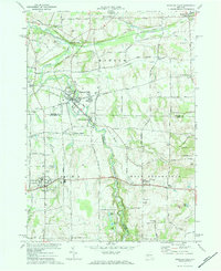
1971 Map of Honeoye Falls
USGS Topo · Published 1973About this map
Honeoye Creek winds through this landscape, marking the transition between the agricultural uplands and the industrial legacy of Honeoye Falls. The village of Honeoye Falls serves as the primary hub, where the topography drops sharply enough to have historically powered local industry. To the north, the Lehigh Valley Railroad corridor intersects at Rochester Junction, a critical point in the regional transport network during this era.
Find a feature on this map
42 named features on this map. Tap any name to fly to it.
Don’t see what you’re looking for? This feature index may not catch every label — zoom into the map to look around manually.
Map Details
Editions of this 1971 Honeoye Falls Map
Other maps of this area

1895 · Rochester
USGS Topo · 1:62,500

1898 · Rochester
USGS Topo · 1:62,500

1900 · Macedon
USGS Topo · 1:62,500

1900 · Canandaigua
USGS Topo · 1:62,500

1901 · Honeoye
USGS Topo · 1:62,500

1903 · Canandaigua
USGS Topo · 1:62,500

1904 · Honeoye
USGS Topo · 1:62,500

1912 · Rochester
USGS Topo · 1:62,500

1920 · Rochester
USGS Topo · 1:62,500

1931 · Mendon Ponds
USGS Topo · 1:24,000