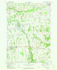
1971 Map of Honeoye Falls
USGS Topo · Published 1973About this map
Honeoye Creek meanders through this landscape, marking a path from North Bloomfield up through the village of Honeoye Falls and toward Sibleyville. By the early 1970s, the region’s transit history is clearly visible in the transition from active lines to memory, with the Lehigh Valley tracks still present while an Old Railroad Grade and the Lehigh Valley Railroad Grade trace former paths of commerce. This survey captures a moment of suburban transition and agricultural persistence across the Monroe, Livingston, and Ontario county lines. Genealogists will find several burial grounds noted, including St Pauls Cem, Rural Cem, and Pioneer Cem. The presence of several named crossroads like Moran Corner, Commins Corners, and Tomlinson Corners highlights the early settlement patterns that defined these townships before more modern development.
Find a feature on this map
42 named features on this map. Tap any name to fly to it.
Don’t see what you’re looking for? This feature index may not catch every label — zoom into the map to look around manually.
Map Details
Editions of this 1971 Honeoye Falls Map
Other maps of this area

1895 · Rochester
USGS Topo · 1:62,500

1898 · Rochester
USGS Topo · 1:62,500

1900 · Macedon
USGS Topo · 1:62,500

1900 · Canandaigua
USGS Topo · 1:62,500

1901 · Honeoye
USGS Topo · 1:62,500

1903 · Canandaigua
USGS Topo · 1:62,500

1904 · Honeoye
USGS Topo · 1:62,500

1912 · Rochester
USGS Topo · 1:62,500

1920 · Rochester
USGS Topo · 1:62,500

1931 · Mendon Ponds
USGS Topo · 1:24,000