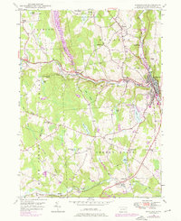
1946 Map of Honesdale
USGS Topo · Published 1976About this map
Honesdale and the surrounding townships of Dyberry, Cherry Ridge, and Clinton are defined by the convergence of industrial infrastructure and rural settlement patterns. The Lackawaxen River and Dyberry Creek anchor the local geography, providing the valley floor where the Erie railroad once facilitated movement alongside the Roosevelt HY. Genealogists will find a wealth of specific identifiers, including numerous denominational burial grounds such as St Marys Cem and St Johns Cem, as well as several smaller family or local sites like Keen Cem and Schoonover Cem. The 1969 revisions highlight significant landscape changes, most notably the General Edgar Jadwin Dam and its associated inundation area. Smaller outlying settlements and former school sites like Fermoy Sch and Hoadley Sch remain preserved here, offering a clear view of Wayne County's development from the mid-1940s through the late 1960s.
Find a feature on this map
55 named features on this map. Tap any name to fly to it.
Don’t see what you’re looking for? This feature index may not catch every label — zoom into the map to look around manually.
Map Details
Editions of this 1946 Honesdale Map
4 editions found

Other maps of this area

1892 · Honesdale
USGS Topo · 1:62,500

1920 · Damascus
USGS Topo · 1:62,500

1923 · Damascus
USGS Topo · 1:62,500

1928 · Ariel
USGS Topo · 1:62,500

1932 · Ariel
USGS Topo · 1:62,500

1935 · Hawley
USGS Topo · 1:62,500

1938 · Hawley
USGS Topo · 1:62,500

1943 · Honesdale
USGS Topo · 1:125,000

1944 · Damascus
USGS Topo · 1:62,500

1946 · Forest City
USGS Topo · 1:24,000