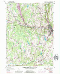
1946 Map of Honesdale
USGS Topo · Published 1989About this map
Honesdale serves as the focal point of this Wayne County landscape, situated at the confluence of Dyberry Creek and the Lackawaxen River. The 1946 topography, updated with 1969 aerial data, reveals a community deeply rooted in its valley setting, where the Roosevelt Highway and an Old Railroad Grade trace the water's path. In the surrounding highlands, small settlements like Prompton, Bethany, and Seelyville are linked by a network of rural roads and dotted with local institutions, including St Patricks Ch and several country schools like Fermoy Sch.
Find a feature on this map
51 named features on this map. Tap any name to fly to it.
Don’t see what you’re looking for? This feature index may not catch every label — zoom into the map to look around manually.
Map Details
Editions of this 1946 Honesdale Map
4 editions found

Other maps of this area

1892 · Honesdale
USGS Topo · 1:62,500

1920 · Damascus
USGS Topo · 1:62,500

1923 · Damascus
USGS Topo · 1:62,500

1928 · Ariel
USGS Topo · 1:62,500

1932 · Ariel
USGS Topo · 1:62,500

1935 · Hawley
USGS Topo · 1:62,500

1938 · Hawley
USGS Topo · 1:62,500

1943 · Honesdale
USGS Topo · 1:125,000

1944 · Damascus
USGS Topo · 1:62,500

1946 · Forest City
USGS Topo · 1:24,000