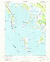
1942 Map of Honga
USGS Topo · Published 1976About this map
The salt marshes and narrow necks of Dorchester County define this coastal landscape, where the Honga River separates the mainland from a chain of islands. Stretching through the center of the sheet, Upper Hooper Island and Middle Hooper Island are home to traditional waterman communities like Hoopersville and Honga, where multiple spires indicate local churches. The map reflects a maritime economy tied to the Chesapeake Bay, evidenced by a Cannery at Crapo and the small Landing Strip on Wroten Island. This 1942 survey, updated with 1974 revisions, captures the complex interplay of land and water across Meekins Neck and Asquith Island, showing how isolated settlements relied on early state roads like 335 and 336 and boat access through tidal passages like The Canal.
Find a feature on this map
75 named features on this map. Tap any name to fly to it.
Don’t see what you’re looking for? This feature index may not catch every label — zoom into the map to look around manually.
Map Details
Editions of this 1942 Honga Map
3 editions found
Other maps of this area

1892 · Drum Point
USGS Topo · 1:62,500

1894 · Point Lookout
USGS Topo · 1:62,500

1898 · St. Marys
USGS Topo · 1:125,000

1901 · Drum Point
USGS Topo · 1:62,500

1903 · Bloodsworth Island
USGS Topo · 1:62,500

1905 · Crapo
USGS Topo · 1:62,500

1905 · Drum Point
USGS Topo · 1:62,500

1906 · St. Marys
USGS Topo · 1:125,000

1912 · Point Lookout
USGS Topo · 1:62,500

1937 · Point Lookout
USGS Topo · 1:62,500