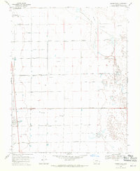
1968 Map of Hooper East
USGS Topo · Published 1970About this map
Hooper and Mosca anchor this 1968 study of the San Luis Valley, where the landscape is defined by a rigid grid of numbered roads and an intricate irrigation network. The terrain is marked by a series of parallel east-west routes, including Elevenmile Lane through Fourmile Lane, which illustrate the systematic agricultural development of the region. Flowing through the eastern portion of the map is San Luis Creek, leading toward the edges of the Great Sand Dunes National Monument. Water management is central to the area's identity, evidenced by numerous features such as the San Luis Valley Irrigation Drain, Gibson Ditch, and Prairie Ditch. The prevalence of Flowing Wells across the quadrangle highlights the heavy reliance on artesian water for ranching and farming during this era of Colorado's history.
Find a feature on this map
24 named features on this map. Tap any name to fly to it.
Don’t see what you’re looking for? This feature index may not catch every label — zoom into the map to look around manually.
Map Details
Editions of this 1968 Hooper East Map
2 editions found
Other maps of this area

1954 · Trinidad
USGS Topo · 1:250,000

1955 · Trinidad
USGS Topo · 1:250,000

1958 · Trinidad
USGS Topo · 1:250,000

1959 · Trinidad
USGS Topo · 1:250,000

1965 · Medano Ranch
USGS Topo · 1:24,000

1965 · Dry Lakes
USGS Topo · 1:24,000
1966 · Mount Pleasant School
USGS Topo · 1:24,000
1966 · Hooper SE
USGS Topo · 1:24,000
1967 · Sand Camp
USGS Topo · 1:24,000
1968 · Deadman Camp
USGS Topo · 1:24,000