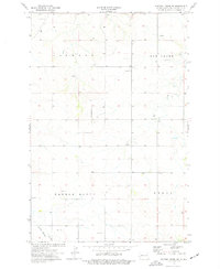
1974 Map of Hootowl Creek SW
USGS Topo · Published 1977About this map
Saddle Butte dominates the southern landscape of this 1970s western North Dakota survey, where the township boundaries of Elmwood and Delhi meet. The terrain is defined by a network of drainage systems including Elk Creek and Little Beaver Creek, which wind through a patchwork of rangeland and resource extraction sites. Local infrastructure is sparse, characterized by a central Townhall and scattered industrial activity marked by various Scoria Pits, Gravel Pits, and a Drill Hole. This map provides a clear record of the rural land divisions and the physical features of Golden Valley County before modern shifts in land use, documenting the precise locations of water sources like a named Spring and numerous wells used by ranchers and early residents.
Find a feature on this map
12 named features on this map. Tap any name to fly to it.
Don’t see what you’re looking for? This feature index may not catch every label — zoom into the map to look around manually.
Map Details
Editions of this 1974 Hootowl Creek SW Map
This is the sole edition of this map. No revisions or reprints were ever made.
Other maps of this area

1909 · Glendive
USGS Topo · 1:250,000

1953 · Miles City
USGS Topo · 1:250,000

1953 · Dickinson
USGS Topo · 1:250,000

1953 · Watford City
USGS Topo · 1:250,000

1954 · Glendive
USGS Topo · 1:250,000

1957 · Dickinson
USGS Topo · 1:250,000

1957 · Miles City
USGS Topo · 1:250,000

1957 · Glendive
USGS Topo · 1:250,000

1957 · Watford City
USGS Topo · 1:250,000

1958 · Miles City
USGS Topo · 1:250,000
Featured Places
- Elk Creek Township, ND
- Saddle Butte Township, ND
- Delhi Township, ND
- Elmwood Township, ND
- Golden Valley County, ND