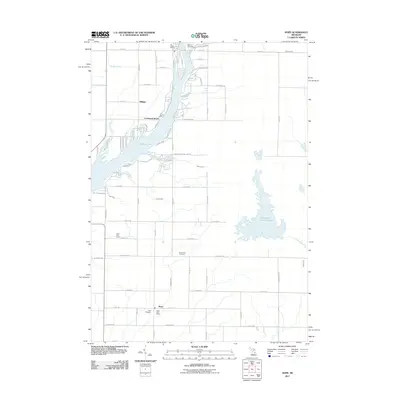
2011 Map of Hope
USGS Topo · Published 2011About this map
The settlement of Hope and its central Hope Post Office anchor this 2011 record of Gladwin County. The landscape is defined by the expansive waters of Wixom Lake, which draws residential clusters like Lockwood Beach, All Bright Shores, and Billings toward its irregular shorelines. This map captures the intricate drainage system of the Tittabawassee watershed, featuring named watercourses like Sturgeon Creek, Denton Creek, and the extensive Kawkawlin Creek Flooding to the east. For genealogists and local historians, several burial grounds are meticulously documented, including Billings Cemetery in the north and the New Hope Cemetery and Hope Cemetery near the southern townships. The transition from agricultural grid roads to the recreational development around the lake provides a clear view of the area's modern land use, from the Gully Golf Course to the numerous residential drives like Paradise Dr.
Find a feature on this map
72 named features on this map. Tap any name to fly to it.
Don’t see what you’re looking for? This feature index may not catch every label — zoom into the map to look around manually.
Map Details
Editions of this 2011 Hope Map
This is the sole edition of this map. No revisions or reprints were ever made.
Other maps of this area

1934 · Sanford
USGS Topo · 1:62,500

1936 · Sanford
USGS Topo · 1:62,500

1954 · Midland
USGS Topo · 1:250,000

1958 · Midland
USGS Topo · 1:250,000

1959 · Midland
USGS Topo · 1:250,000

1962 · Midland North
USGS Topo · 1:24,000

1966 · Midland
USGS Topo · 1:250,000

1969 · Gladwin
USGS Topo · 1:24,000
1969 · Hope
USGS Topo · 1:24,000
1969 · Bentley
USGS Topo · 1:24,000