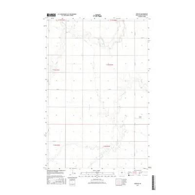
2017 Map of Hope NE
USGS Topo · Published 2017About this map
The Middle Br Goose River and S Br Goose River carve distinct drainage patterns across this rural landscape in Steele County. This 2017 survey by the U.S. Geological Survey illustrates the structured agricultural grid of Sherbrooke Township, defined by the Public Land Survey System boundaries like t146n r54w. Human activity is primarily centered on the network of county roads, including Co Hwy 8 and Co Hwy 10, which connect scattered farmsteads. A notable aviation landmark, the Erickson Airport, sits in the eastern portion of the quadrangle. Water management is evident through features such as the Primrose Drain, which supports the region's long-standing reliance on high-plains agriculture.
Find a feature on this map
16 named features on this map. Tap any name to fly to it.
Don’t see what you’re looking for? This feature index may not catch every label — zoom into the map to look around manually.
Map Details
Editions of this 2017 Hope NE Map
This is the sole edition of this map. No revisions or reprints were ever made.
Other maps of this area

1952 · Grand Forks
USGS Topo · 1:250,000

1956 · Grand Forks
USGS Topo · 1:250,000

1966 · Grand Forks
USGS Topo · 1:250,000

1966 · Galesburg
USGS Topo · 1:24,000

1966 · Hope SE
USGS Topo · 1:24,000

1968 · Hope NE
USGS Topo · 1:24,000
1968 · Galesburg
USGS Topo · 1:24,000

1968 · Sherbrooke
USGS Topo · 1:24,000
1968 · Galesburg NW
USGS Topo · 1:24,000
1968 · Hope
USGS Topo · 1:24,000
Featured Places
- Sherbrooke Township, ND
- Edendale Township, ND
- Enger Township, ND
- Golden Lake Township, ND
- Hugo Township, ND