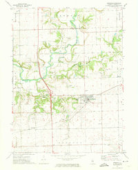
1971 Map of Hopedale
USGS Topo · Published 1973About this map
Hopedale sits at the center of this rural landscape, defined by the winding course of the Mackinaw River and its numerous tributaries. The map reveals a high density of small family and community burial grounds, such as Mennonite Cem, Griesemer Cem, and Sparrow Cem, which offer significant value for genealogical research in this part of Illinois. The transportation infrastructure of the early 1970s is well-documented, featuring the Gulf Mobile and Ohio railroad corridor running through the southern section of the quadrangle. Industrial activity is primarily represented by numerous Gravel Pits concentrated along the riverbanks, illustrating the local reliance on the alluvial deposits of the river valley. The mix of township boundaries like Elm Grove and Boynton provides a clear framework for identifying historic property locations and civic divisions.
Find a feature on this map
31 named features on this map. Tap any name to fly to it.
Don’t see what you’re looking for? This feature index may not catch every label — zoom into the map to look around manually.
Map Details
Editions of this 1971 Hopedale Map
This is the sole edition of this map. No revisions or reprints were ever made.
Other maps of this area

1905 · Peoria
USGS Topo · 1:62,500

1927 · Peoria
USGS Topo · 1:62,500

1928 · Mackinaw
USGS Topo · 1:62,500

1932 · Mackinaw
USGS Topo · 1:62,500

1942 · Delavan
USGS Topo · 1:62,500

1951 · Minier
USGS Topo · 1:62,500

1958 · Peoria
USGS Topo · 1:250,000

1960 · Marquette Heights
USGS Topo · 1:24,000

1961 · Peoria
USGS Topo · 1:250,000

1963 · Peoria
USGS Topo · 1:250,000