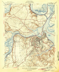
1943 Map of Hopewell
USGS Topo · Published 1943About this map
The confluence of the James River and Appomattox River anchors this 1940 survey, which captures the industrial and military importance of the region during the early years of the Second World War. Hopewell appears as a dense urban core, sprawling toward Highland Park and the historic deep-water port at City Point. The landscape reflects a mix of deep colonial heritage and modern infrastructure, shown through the proximity of the ancient Bermuda Hundred settlement to the expansive Federal Reformatory and the military grounds of Camp Lee. Transportation networks are heavily defined by the Seaboard and Norfolk and Western railroads, which facilitated movement between the riverfronts and the interior. Rural life persists on the fringes at Screamersville and Meadowville, while features like the Walthall Mill on Ashton Creek and several country schools including Ochre Sch point to the area's agricultural past.
Find a feature on this map
57 named features on this map. Tap any name to fly to it.
Don’t see what you’re looking for? This feature index may not catch every label — zoom into the map to look around manually.
Map Details
Editions of this 1943 Hopewell Map
3 editions found
Other maps of this area

1894 · Bermuda Hundred
USGS Topo · 1:62,500

1894 · Petersburg
USGS Topo · 1:62,500

1918 · Charles City
USGS Topo · 1:62,500

1919 · Disputanta
USGS Topo · 1:62,500

1938 · Dutch Gap
USGS Topo · 1:24,000

1938 · Drewrys Bluff
USGS Topo · 1:24,000

1943 · Dutch Gap
USGS Topo · 1:31,680

1943 · Hopewell
USGS Topo · 1:31,680

1943 · Disputanta
USGS Topo · 1:31,680

1943 · Richmond
USGS Topo · 1:250,000