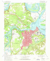
1969 Map of Hopewell
USGS Topo · Published 1971About this map
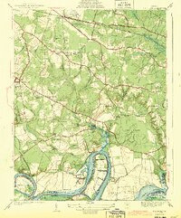
The James River and Appomattox River confluence defines this late-1960s landscape, where industrial expansion meets deep-rooted Tidewater history. The city of Hopewell serves as the focal point, characterized by its dense street grid and significant riverfront infrastructure including a large Filtration Plant and industrial waste ponds. To the west, the Fort Lee Military Reservation and the Federal Reformatory occupy substantial acreage, while the S C L railroad line cuts through the historic settlements of Bermuda Hundred and Screamersville. The map also preserves the site of several breastworks, hinting at the area's strategic defensive importance in previous centuries. Along the northern bends of the James, the Presque Isle National Wildlife Refuge provides a sharp contrast to the nearby Gravel Pits and suburban developments of Kenwood and Highland Park.
Find a feature on this map
92 named features on this map. Tap any name to fly to it.
Don’t see what you’re looking for? This feature index may not catch every label — zoom into the map to look around manually.
Map Details
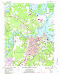
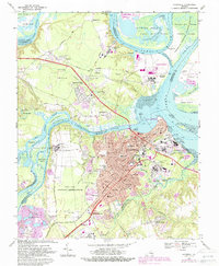
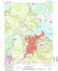
Editions of this 1969 Hopewell Map
4 editions found
Other maps of this area

1894 · Bermuda Hundred
USGS Topo · 1:62,500

1894 · Petersburg
USGS Topo · 1:62,500

1918 · Charles City
USGS Topo · 1:62,500

1919 · Disputanta
USGS Topo · 1:62,500

1938 · Dutch Gap
USGS Topo · 1:24,000

1938 · Drewrys Bluff
USGS Topo · 1:24,000
1943 · Dutch Gap
USGS Topo · 1:31,680

1943 · Hopewell
USGS Topo · 1:31,680

1943 · Disputanta
USGS Topo · 1:31,680

1943 · Richmond
USGS Topo · 1:250,000